A rapidly intensifying low pressure system in the Bay of Bengal is steering unstable weather toward Sri Lanka, raising fears of heavy rain, depression formation and possible cyclone development as the region’s climate engine roars to life.
Why the Bay of Bengal Becomes So Violent
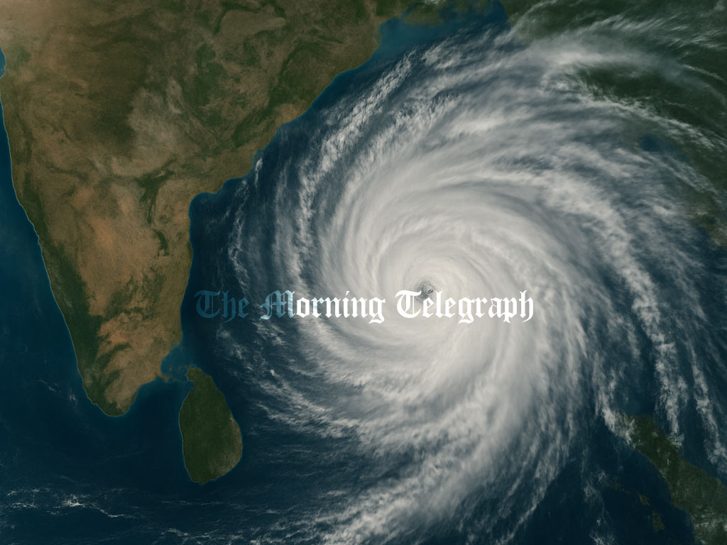
Sri Lankans are familiar with warnings that the Bay of Bengal has turned turbulent, especially during periods of heavy rain and shifting winds. With a new low pressure zone developing southeast of the island and forecast to grow into a depression within twenty four hours before drifting northward and northwestward, public focus has returned to meteorological updates. To understand why this region repeatedly produces violent weather and why it affects Sri Lanka so significantly, Additional Director General Anusha Warnasuriya explained the deeper forces shaping conditions over the Bay of Bengal.

Depressions and cyclones form over this sea area almost every year. These systems influence not only Sri Lanka but also India and Bangladesh. According to Warnasuriya, the Bay of Bengal is a crucial component of the global climate system. Climate is shaped by the interaction of land, sea, atmosphere, glaciers and the biosphere. These elements work together as one global system. Because of this, the Bay of Bengal influences weather patterns far beyond the region.
She explained that rising sea temperatures destabilize the atmosphere above the water. Sri Lanka is sandwiched between the Arabian Sea and the Bay of Bengal. This unique position exposes the island to shifting wind flows from both sides. These winds generate turbulence over the ocean and contribute to global climate balance. Although disturbances in the Arabian Sea can also affect Sri Lanka, the majority of the island’s heavy rainfall and storm activity originates from the Bay of Bengal. Its warm waters and strong wind patterns consistently drive weather toward the island, shaping entire seasons.
How Low Pressure Areas Actually Form
People often hear the term low pressure area but may not understand what it represents. Warnasuriyakaruna explained that a low pressure zone forms when the atmospheric pressure in a specific location decreases. Winds always move from high pressure toward low pressure. When the land or sea surface heats up, the air above it becomes lighter and rises. This rising air leaves behind a low pressure space. Winds from surrounding regions then flow in to balance the pressure. This process creates instability.
As warm air continues to rise and surrounding winds rush in, the system gains strength. If these conditions persist, the low pressure area begins to organize itself, grow wider and can eventually evolve into a more powerful weather system. This is how the building blocks of storms are created.
How These Systems Turn Into Storms
Warnasuriya emphasized that a cyclone forms gradually. It does not emerge all at once. She compared its development to a child growing into an adult. First there is a disturbance, then a low pressure zone, then a depression. As wind speeds increase around the core, it transforms into a cyclone. With further intensification, it may even reach super cyclone status. Every stage reflects a growth in structure and energy. Meteorologists watch these transitions closely because stronger systems can develop within short periods when ocean temperatures are high.
Why Rainfall Uses Millimeters
Rainfall measurement follows global scientific standards. All meteorological departments worldwide use similar instruments so that data from different places can be compared accurately. Millimeters are the accepted international unit for measuring rain. This helps researchers study patterns, track storms and analyze long-term changes with consistency.
Could Sri Lanka Face a Cloudburst?
Cloudbursts are sudden, extreme rainfall events that release massive volumes of water in a very short time. This year, cloudbursts hit regions in the United States, India and Pakistan. When asked whether Sri Lanka could face a similar threat, Warnasuriya explained that cloudbursts cannot be predicted in advance. These events usually form in mountainous areas.
For rain to occur, moisture from the ground must rise, condense and cool. Mountains help lift moist air upward quickly. When strong moisture-laden winds hit mountain slopes, huge cloud formations can develop rapidly. These clouds can grow up to twelve kilometers in height. Once saturated, they release torrential rain within minutes. Similar events this year brought destruction in multiple countries. Sri Lanka’s central highlands create the right environment for such conditions if moisture and wind patterns align. The risk exists but foreseeing it before it happens is extremely difficult.
As the current low pressure system intensifies over the Bay of Bengal, Sri Lanka remains vulnerable to heavy rainfall and potential storm escalation. The region’s warm waters and atmospheric instability ensure that it will continue to influence the island’s weather patterns. Understanding how these systems form helps explain why Sri Lanka repeatedly faces sudden storms, unpredictable rainfall and the ongoing threat of rapid cyclone development.